Why NepalPick recommends it
Why Nar & Phu rewards curiosity
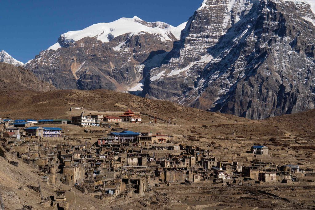
Leave the busy circuit for narrow gorges, high pastures, medieval style settlements, and the option to cross Kang La back toward Manang.
The journey offers space to notice how the landscape changes, eat what is seasonal, and let local knowledge shape the day. The point is not to collect sights. It is to understand why this place feels different from Nepal’s familiar routes.
A restricted area with significant altitude, travel with proper acclimatisation and local support.
Complete planning guide
Planning Nar & Phu: itinerary, logistics, weather, and costs
Research-based framework, last reviewed 14 July 2026. Operational details — roads, flights, lodges, permits, fees — change; items marked for verification must be reconfirmed before booking.
Recommended13 days11–15 days; Kang La exit only in safe conditions
Start / endKathmandu → Besisahar → Koto → Phu → Nar → Kang La → Ngawal → Besisahar → Kathmandu
Highest pointKang La, approximately 5,320 m
Trip stylelodge trekExperienced trekkers with prior altitude history: a short route by days, a serious one by pass height.
Two medieval-feeling stone villages hidden north of the Annapurna corridor: Phu's fortress terraces and Nar's pastoral amphitheatre, joined to Manang by the high Kang La. A restricted enclave of Tibetan Buddhist life that the highway of the Circuit rushes straight past.
Getting there: preferred and alternative routes
PreferredKathmandu → Besisahar → Koto
Road (highway then jeep track) · 6–8 hours + 5–7 hours jeep · overnight: Besisahar or Koto
- Works because
- Continuous road corridor, no flights
- Trade-off
- The Besisahar–Koto jeep stage is long and rough
- Vulnerable to
- Monsoon damage on the Marsyangdi road
- Book
- Agency jeeps
- Reconfirm locally
- Road status beyond Besisahar and checkpost hours at Koto
AlternativeReturn via Koto instead of Kang La
Walking (reverse the entry) · Saves nothing but avoids the pass
- Works because
- The safe exit when snow, wind, or group condition rules out the crossing
- Trade-off
- Retraces the gorge; misses Nar-to-Manang linkup
- Vulnerable to
- Low — that is the point
- Book
- —
- Reconfirm locally
- Decide at Nar with your guide, not in Kathmandu
No flight, road, bridge, or lodge on this page is promised to operate on a given day — that is Nepal, honestly stated. Build the margins this page recommends.
Day by day
Day 1Kathmandu → Besisahar → toward KotoFull road day
Morning: Highway to Besisahar, then the jeep track north.
Route and pace: Long; break at Besisahar if late.
The experience: The Marsyangdi corridor compressing from rice to pine.
Overnight and meals: Koto (or Chame) lodge.
Key risk / decision: Road fatigue; jeep stage after dark is a mistake.
Fallback: Split with a Besisahar night, using a contingency day.
Day 2Koto → Meta6–8 hours walking · approx. 3,560 m
Morning: Register at the checkpost, cross the Marsyangdi, and enter the Nar Phu gorge.
Route and pace: Long, wild, committing — forest ledges, river crossings, one dramatic waterfall-cave passage.
The experience: The gorge is the door: by evening the Annapurna crowds are a rumour.
Overnight and meals: Basic lodge at Meta on its open plateau.
Water: Sources en route; treat.
Key risk / decision: Big single-day gain — the route's first altitude test.
Fallback: Seasonal shelter mid-gorge splits the day when open.
Day 3Meta → Phu5–7 hours walking · approx. 4,080 m
Morning: Through Kyang's winter-village ruins along river flats.
Route and pace: Altitude-slow; wind funnels the canyon by afternoon.
The experience: Phu's gateway kani and fortress hill — a settlement seemingly grown from its rock.
Overnight and meals: Community lodge in Phu.
Key risk / decision: Sleeping over 4,000 m on night three demands honesty about symptoms.
Fallback: Extra night at Meta if the group needs the curve flattened.
Day 4Phu acclimatisation2–4 hours optional
Morning: Climb toward Himlung Base Camp viewpoints or sit with the village's rhythm.
Route and pace: Gentle.
The experience: Tashi Lhakhang gompa and Phu's fields — a working medieval economy at 4,000 m.
Overnight and meals: Phu again.
Key risk / decision: —
Fallback: Full rest as needed.
Day 5Phu → Nar Phedi5–6 hours walking · approx. 3,490 m
Morning: Retrace briefly, then contour to the monastery at Nar Phedi.
Route and pace: Descending day — recovery built into the route.
The experience: The nunnery-monastery takes guests: dinner cooked by nuns, prayers at dusk if invited.
Overnight and meals: Monastery guesthouse, Nar Phedi.
Key risk / decision: None unusual.
Fallback: —
Day 6Nar Phedi → Nar2–3 hours walking · approx. 4,110 m
Morning: Short switchbacking climb past painted chortens.
Route and pace: Half-day by design — altitude and culture share it.
The experience: Nar's amphitheatre of barley terraces, yak herds, and four gompas.
Overnight and meals: Lodge in Nar.
Key risk / decision: Second 4,000 m sleeping night; the pass decision forms tonight.
Fallback: Extra Nar day fits here (contingency).
Day 7Nar acclimatisation + pass decision2–4 hours optional
Morning: Ridge walk toward Kang La's approach to preview conditions.
Route and pace: Gentle, purposeful.
The experience: Village life plus a clear-eyed look at tomorrow.
Overnight and meals: Nar.
Key risk / decision: The go/no-go: snowline, wind, group condition — guide's call is final.
Fallback: Exit via Koto if no; nothing is lost but symmetry.
Day 8Nar → Kang La → Ngawal8–10 hours walking · pass approx. 5,320 m
Morning: Alpine start (3–4 a.m.) up moraine ramps to the prayer-flagged notch.
Route and pace: Slow, rhythmic, cold — then a long scree descent into Manang's arid bowl.
The experience: From the pass: Annapurna II–IV filling the sky. One of Nepal's great single-day transitions.
Overnight and meals: Comfortable lodge in Ngawal — the Circuit's amenities feel decadent tonight.
Water: Carry the day's full supply; nothing reliable en route.
Key risk / decision: The crux day: altitude, weather exposure, and a knee-eating descent. Turn back early if the window closes.
Fallback: Retreat to Nar and exit via Koto — pre-agreed as the no-drama plan B.
Day 9Ngawal → Chame corridor4–6 hours walking or jeep mix
Morning: Descend the upper Circuit trail through Pisang.
Route and pace: Easy gradient, thick air, fast progress.
The experience: The strange sociability of the Circuit after the enclave's silence.
Overnight and meals: Chame or Koto lodge.
Key risk / decision: None unusual.
Fallback: Jeep options exist most of the way if time is short.
Day 10Chame/Koto → Besisahar5–7 hours jeep
Morning: The long track down the Marsyangdi.
Route and pace: —
The experience: Gorge scenery you climbed through, now unspooling backward.
Overnight and meals: Besisahar.
Key risk / decision: Road conditions after rain.
Fallback: Day 12–13 buffer.
Day 11Besisahar → Kathmandu6–8 hours road
Morning: Highway home.
Route and pace: —
The experience: Done.
Overnight and meals: Kathmandu.
Key risk / decision: —
Fallback: —
Day 12Contingency day 1—
Morning: Unassigned.
Route and pace: —
The experience: Pass-wait at Nar or road margin.
Overnight and meals: —
Key risk / decision: —
Fallback: —
Day 13Contingency day 2—
Morning: Unassigned.
Route and pace: —
The experience: Second buffer.
Overnight and meals: —
Key risk / decision: —
Fallback: —
Weather through the year
| Season | Typical character | Trails, roads, lodges, flights | Think twice if |
|---|
| Mar–May | Spring: warming valleys, Kang La usually opening mid-April onward; wind builds afternoons. | Lodges reopen; verify pass snowpack early season. | Early-March parties without winter capability. |
| Jun–Aug | Rain-shadow advantage: the enclave stays relatively dry while the access road suffers monsoon damage. | The road is the problem; the valleys themselves are summer-walkable — a legitimate niche season with an agency that knows it. | Anyone unwilling to gamble the Besisahar–Koto road. |
| Sep–Nov | Prime: stable air, clear pass windows, cold high nights from late October. | Best all-round; permit rate is at its seasonal peak. | Nobody. |
| Dec–Feb | Deep cold; Kang La effectively closed to normal parties; villages part-empty for winter. | Out-and-back to Phu/Nar possible for hardy parties; the crossing is not. | All but winter-specialist teams. |
Seasonal patterns, not forecasts. Temperatures vary dramatically with altitude on the same day — pack by elevation range.
Things to do
- Phu's fortress village and Tashi Lhakhang gompa
- Nar's terraced amphitheatre and four gompas
- A night in Nar Phedi monastery
- Kang La and its Annapurna panorama
- Himlung viewpoint walks
- The Nar Phu gorge passage itself
On the ground
Accommodation
Basic community lodges in Phu and Nar, the monastery guesthouse at Nar Phedi, comfortable Circuit lodges from Ngawal. High-village lodges thin outside main season — verify.
Food and water
Lodge staples with yak-dairy accents high. Pass-day packed lunch essential. Treat everything.
Connectivity and power
Sporadic signal to Koto, effectively none in the enclave. Paid solar charging in villages. Guide carries comms.
Cash and payments
Cash from Besisahar onward for everything.
Permits and guide requirements
| Requirement | Amount | Authority | Note |
|---|
| Nar-Phu Restricted Area Permit (Manang) | Sep–Nov: USD 100/week; Dec–Aug: USD 75/week; then USD 15/day beyond a week (official baseline as of 14 July 2026 — recheck) | Department of Immigration via registered agency | Agency-issued; the priciest week-rate in this collection — season choice changes cost meaningfully. |
| Annapurna Conservation Area entry | Verify current NPR fee | ACAP / NTNC | Required alongside the restricted permit; the exit through Ngawal is inside ACAP. |
Guide requirement: Licensed guide through a registered agency mandatory — restricted area. The Kang La decision is the hire's defining moment: choose experience over price.
What it costs
| Band | USD (per person) | NPR (approx.) | What it buys |
|---|
| Recommended guided | USD 1,200–1,800 | NPR 184,000–NPR 276,000 | Agency service, permits, guide/porter, transfers, lodges — winter-rate seasons cheaper, autumn dearer. |
| Higher comfort / private | USD 1,800–2,200 | NPR 276,000–NPR 337,000 | Private transport, extra acclimatisation nights, small-group staffing. |
Main cost drivers
- Seasonal restricted permit
- ACAP fee
- Guide and porter
- Long jeep stages
Typically included
- Transfers
- Permits
- Guide and porter with insurance
- Lodges and trek meals
Not included
- International airfare, visa, insurance explicitly to 5,320 m
- Kathmandu nights, tips, gear rental
Contingency: 15–25% — a 5,300 m pass and a fragile road each demand margin. No independent band: restricted area.
Planning ranges per adult, twin-share, for the recommended duration from the stated gateway — not quotes. NPR conversion uses the Nepal Rastra Bank selling rate of USD 1 = NPR 153.3 reviewed 31 August 2026, rounded to the nearest NPR 1,000; bank, card, and cash rates differ. Excludes international airfare, visa, insurance, tips, and personal spending unless stated.
Packing essentials for this route
- Four-season bag (−15 °C comfort)
- Full pass kit: down, shell, microspikes, insulated bottle
- Sun protection for high-desert glare
- Water treatment
- Headlamp with spare cells for the alpine start
Safety and contingency
- Ascend conservatively: once above 3,000 m, keep sleeping-elevation gains modest and build in acclimatisation days as scheduled.
- Learn the symptoms of acute mountain sickness before departure and agree turnaround rules with your guide — descent is the treatment.
- Helicopter evacuation depends on weather, daylight, and insurance; carry insurance that explicitly covers your maximum altitude and confirm the emergency process with your operator.
- Treat all drinking water; carry a filter or purification tablets rather than relying on bottled supply.
- Kang La at 5,320 m is this collection's highest point after Pangpema — prior altitude experience is a fair prerequisite, not gatekeeping.
- The alpine start is a safety tool: afternoon wind on the pass is a schedule, not a possibility.
- Pre-agree the Koto exit as plan B so nobody bargains at 5,000 m.
If things change: Two days built in; the pass-wait at Nar is their designed purpose. The abbreviation — out-and-back via Koto — preserves every cultural highlight and drops only the crossing.
Accessibility
Not accessible for mobility-limited travellers under any variant.
Travelling responsibly here
- Monastery guesthouse etiquette at Nar Phedi: quiet hours, modest dress, genuine donations.
- Photograph villagers, herds, and gompas only with consent.
- Yak-dung fuel is the local economy — buy meals at your lodge rather than importing everything.
- Pack out all non-organics; the enclave has no waste chain.
Booking checklist
- Registered agency with recent Nar-Phu departures
- Permit rate confirmed for your season band
- Road status Besisahar–Koto for your dates
- Insurance stated to 5,320 m with heli evacuation
- Pass plan B agreed in writing
- Full cash from Kathmandu
Sources
Research draws on the following, alongside NepalPick’s editorial method. Last reviewed 14 July 2026; recheck official sources on the day you book.